River basin

On an annual basis (neglecting changes in storage) the discharge from a river basin into the sea equals total precipitation (rain, etc) minus the actual evapotranspiration.
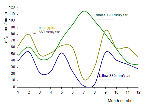
The top right figure shows the actual evapotranspiration for three land uses in the Roxo basin in south Portugal, as quantified through the energy balance of the pixels of Landsat and Modis images. Please note that ETa is given for the full year and not just for the crop growing season, because water also evaporates when there is no crop in the field. To illustrate this water consumption, The figure shows the annual ETa from fallow land as being 380 mm/year. This is 155 mm/year less than the annual precipitation of 535 mm/year. This non-consumed water either runs off into streams or recharges the groundwater basin. Fallow land, however, does not yield a crop and is not appealing from a tourist point of view. Eucalyptus forest performs better on both counts. As shown, it consumes 660 mm/year, being 125 mm/year more than the annual rainfall. The forest thus takes water out of storage (from the groundwater basin). Contrary to common belief, planting forest is not a water conservation activity in this climate. For irrigated maize, water consumption increases to 790 mm/year, being 255 mm/year more than the precipitation and 410 mm/year more than the figure for fallow land. Consumption is about the same if winter wheat is grown before an irrigated crop on the same field. The percentage distribution of these (and other) land uses in the river basin thus influences the volume of water flowing from the basin.
The concept:
Precipitation is the source of all water on the river basin. Water for use is “taken” either directly from this precipitation or from storages convenient for abstracting water, for example, the root zone, a lake, a river or the groundwater basin. Part of the used water is consumed to sustain life; the remainder is discharged to a variety of downstream water storages. These storages, in turn, serve as the water source for downstream users. So water that is not consumed by one user becomes the water source for another. Water thus cascades through the river basin towards the user farthest downstream. It should be realised that development whereby the upstream consumption of water (ETa) increases always results in a decrease in water resources for downstream use. This causes problems in river basins where almost all water is already consumed (negligible flow into the sea) or where the river has no outlet to an ocean. In such river basins, the discharge from a (sub-) river for a ”long” period equals:
Q = precipitation – actual evapotranspiration
Water availability thus can be calculated if data on precipitation are available and if the actual evapotranspiration can be quantified using satellite remote sensing. The list of publications gives several references on this work.
